Day 2, we hired a car, because Jaws had been shot in all the farthest corners of the island. This part looks at the south and west of the island. In the map, you can see two roads forking down from Edgartown. We first headed south on the Katama Road down to Katama Point that juts out into Katama Bay. We then doubled back and took the other fork down to the easternmost end of South Beach. We then headed inland and crossed the island to Menemsha. Then we looped south around Menemsha 'pond' to get to the westernmost point of the island, the cliffs at Aquinnah...
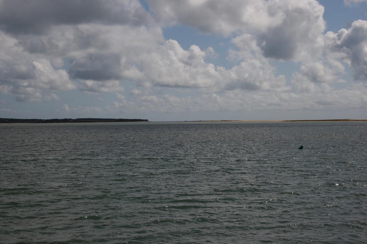
KATAMA BAY
This stretch of water is almost a lagoon, there's a very narrow strait as it passes by Edgartown. The sand spit that once joined Martha's Vineyard to Chappaquiddick has also breached (not sure exactly where). But Katama Bay is almost completely protected from the sea, making it an ideal shooting location when the crew became exasperated by filming up at the State Beach in the sea.
Nothing here is recognisable from the film, but it gave us a good idea of how much easier it was to shoot on the water here. The main drawback was being surrounded by land. There's no problem for any angles looking straight down at the water, but Spielberg also reasoned that the Orca was getting close to home by the end, so a coastline would be visible in the distance. It's the shores of Katama Bay that can be glimpsed towards the end of the movie.
 |
Looking north from Katama Point - the white houses around the bay can be seen in behind-the-scenes photos of the film's climax
 |
| Looking east at the southern tip of Chappaquiddick as it meets the sand spit. On the other side of the sand is the sea |
|
 |
| Looking south - the Bay is very shallow (note the fisherman in the distance), allowing the crew to stage the complex boat-sinking and final duel, but minimise the danger |
SOUTH BEACH
Again, no chance of any landmarks along this stretch of sand and sea, but this is the beach where the opening bonfire was shot and Chrissie runs off. It's also the location of the discovery of her body... (Chrissie in the water was shot over at Cow Bay).
Of course, we had to give it a look and luckily found some of
that fencing.
 |
| Don't say cheese, say "Chrissie!" |
 |
| You can't say she wasn't warned |
 |
| Looking East along South Beach, in the distance, the coast curves around along the horizon |
MENEMSHA
We drove north/inland and then west along the Edgartown - West Tisbury Road to the other side of the island. At the end of the road, we turned left into South Road and through Chilmark. We stopped off at the
Abel Hill cemetery to pay our respects to John Belushi. South Road hits a crossroads called Beetlebung Corner where we headed north a short way to get to Menemsha.
Driving down into Menemsha ends with these two buildings on the right. The Galley restaurant and a store now bookmark either side of the site where Quint's shack was built for the film. It's still a vacant lot. The production team were ordered to dismantle the building immediately after filming. It only ever existed for less than two weeks. As I showed
in the previous article, the art gallery in Edgartown inspired its look. All that's left is a patch of grass at the end of the dock. The restaurant (above left) was also a vacant lot when the film was made.
 |
| End of the dock - the grass in the middle is where Quint's 'shack' stood. The store is on the left, The Galley restaurant on the right is new |
 |
| Side view of the empty lot, looking around the restaurant (at right) |
 |
| From where Quint's shack stood, looking out to sea - as you can see at the end, the Orca would have to zigzag to the left to get out of the dock |
 |
| The house behind my head is where the next two shots were taken from... |
 |
| Looking down on the dock, approximately where we see the Orca set sail, travelling left to right |
 |
| A little to the right - this downward view is quite restricted because of housing. Menemsha Pond is in the background |
 |
| Other side of the dock, looking back towards the restaurant (next to the patch of grass), just to give you an idea that this place is still all about the fishing! |

Menemsha has only a few buildings, but is a perfect natural harbour. The huge pond is also where the Orca and the huge flat barge used as a filming platform were initially laid to rest (until they were more recently relocated away from souvenir-hunters).
 |
| The open sea awaits, the narrow dock is off to the right of this pond
|
AQUINNAH
Driving south from Menemsha, we hit Beetlebung crossroads again, but took the South Road heading west. The road loops around the huge Menemsha Pond and heads northwest to the very tip of the island. This is a popular tourist destination for the scenic view of the cliffs and another of the island's five lighthouses. But that's not why we went...
 |
| The idyllic Gay Head cliffs at Aquinnah. Not sure where they got the name... |
This is where the Mayor, Police Chief Brody and Hooper argue about keeping the beaches open, referencing the defaced 'Welcome To Amity' hoarding of the girl on a surfboard...
 |
| Down the road from the car park, these two benches are next to where the hoarding stood. The scene ends with Hooper sitting on a large rock |
 |
| Using a portable DVD player, this is a location that David triangulated from the lighthouse, the telephone pole and that side-turning off the road |
 |
| Looking towards where the hoarding stood. There are still two benches, but these have changed positions since the film. |
 |
| We approximated this angle. Pretend I'm Murray Hamilton... |
 |
| Perhaps this is the rock where Richard Dreyfuss sat? Down in the distance is a sandy beach referred to in the argument. It's a looooong way away. |
There you have it, folks. A stretch of water, a beach, two patches of grass and a couple of benches. Doesn't look too exciting.
But this is all that's left. Usually filming locations are instantly recognisable, but as you can see, this isn't so easy with
Jaws. It still gave me a far better understanding of how the film was made - what was actually there and what was faked for the film. Also the conditions they filmed in. Locations of the behind-the-scenes photos are certainly more recognisable knowing how the island is laid out.
For the last part of this three-part photo-tour of Martha's Vineyard, we look at the
Jaws locations on the north and east coasts of the island, including a visit to the Brody residence...
Jaws filming locations - part one: Edgartown
The Making of Jaws: if you want to know more, here's where to look
Memories From Martha's Vineyard: jawesome book of islanders' photos taken during filming in 1974( All photographs in this post are copyright of Mark Hodgson and David Tarrington © 2011 )


This is a really great post. Thanks for the wonderful photos.
ReplyDeleteThank you for looking! Location hunts are always fun.
ReplyDeleteGreat site with great photos. I'm visiting Martha's in December and I'm hoping to take in as many locations as possible. Thank you for the insight of what to expect
ReplyDeleteYou're welcome! Look out for guided tours, run from the centre of Edgartown.
ReplyDeleteWas the beginning of Jaws: The Revenge filmed in Menemsha?
ReplyDeleteI went to Martha's Vineyard this past summer and seen all of the locations. Loved it
ReplyDeletemark ames
Feel free to see them on my FB page
ReplyDeleteMark Ames